
Where is Resolfen?
 Resolfen from Craig-y-Nedd
To those of you who do not know where Resolfen/Resolven is. We will try and give you a brief overview and some very basic sketch maps (apologies) so that you may locate some of the places mentioned in the article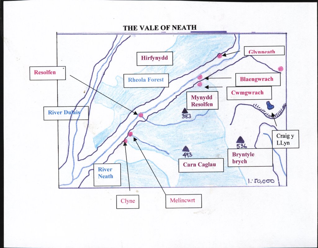 s.
s.
Resolfen is a typical post- industrial Welsh mining village situated some six miles from the main town, Neath in the County Borough of Neath Port Talbot, south Wales. It has a population of some 2,500 including schoolchildren and the main employer is the American motor part manufacturer TRW (still known locally as Cam Gears). The electoral ward includes Resolfen, Melincwrt, Clyne, Abergarwed and Ynysarwed.Some 18% of the village population is Welsh speaking and the community is predominantly a working class one. The local collieries and pits : Glyncastle, Ffald-y-dre , Garth Merthyr and Ynysarwed , produced over three million tons of coal since 1837, but they are now long closed. The aluminium works at Rheola closed in the early 1980s and its remnants are now a weekend market. However, Resolfen possesses a vibrant community and boasts a rugby, soccer, cricket and two bowls clubs. It also has several chapels and churches , a community centre, a Miner's Welfare, British Legion and two public houses. The completion of the A465 missing link trunk road in 1996 has made the area attractive for commuters and recently house prices have seen a dramatic rise as elsewhere in south Wales. The housing (see above photograph)is an interesting feature of the village in that it contains terraced company housing named after local coal owners ( common in the eastern valleys) and also the detached and semi detached pennant sandstone housing so typical of the more affluent anthracite coalfield of west Wales, where many of the colliers were also part time smallholders in the nineteenth and early twentieth century. However, approximatey half the village is now council housing which was built from the late 1940s onwards.
The name 'Resolfen' is rather a mystery since it does not have a ready meaning in either English or Welsh. Suffice to say, for most of its existence the area was known as Ynysfach(small clearing or Island). As with many settlements the Great Western Railway were to blame for rechristening the village when they took the name of the adjacent mountain Mynydd Resolfen for their railway station. Further scrutiny, by local historian Mr Phylip Jones indicates that the probable derivation is a corruption of 'parsel soflan' ( an area of poor grazing land or stubble) situated nearer Cwmgwrach than present day Resolfen. Also, it is fair to note that the area was very spasely populated prior to the arrival of primary industry to the area in the late eighteenth century and was composed of scattered farmsteads and households.
Th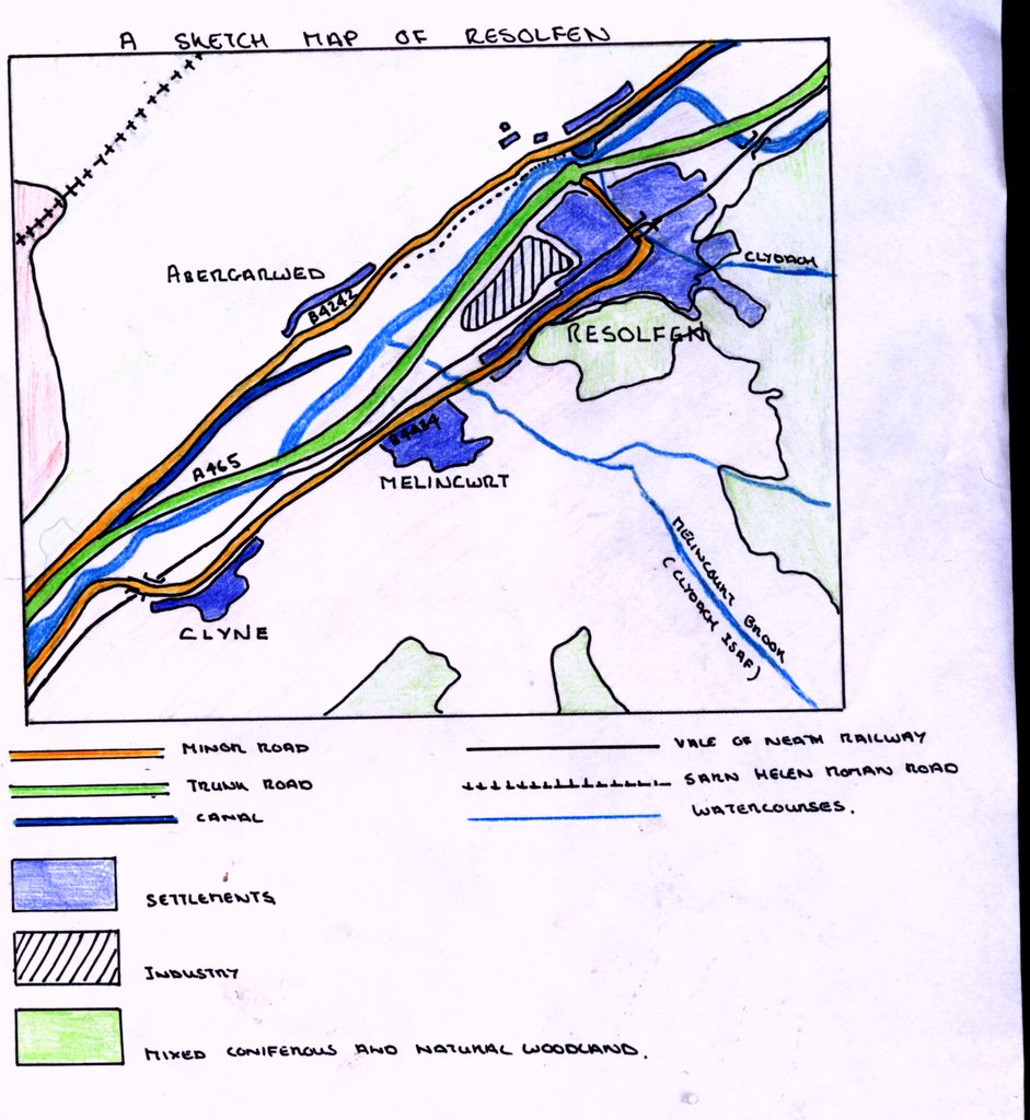 e communications of the area span from Roman times. A Roman road, the Sarn Helen runs along the the ridge of Hirfynydd, including the remains of a signalling station. The Neath canal built by Thomas Dadford in 1797 runs through the village and is mostly restored by a combination of voluntary and official efforts over the last twenty years, and includes an impressive basin . The Vale of Neath railway still operates as a freight line and was built by Isambard Kingdom Brunel to carry coal from the Cynon and Neath valleys for export from Swansea docks. Resolfen boasts an aqueduct which carries the river Clydach Uchaf over the railway and was reputedly constructed by Brunel himself . The A465 dual carriageway was also notorious as, until its completion in 1996, was known as the 'missing link' in the Heads of the Valleys road. The dangerous section ( now the B4242) was the scene of over two hundred road accidents in twenty years and dozens of deaths. Some lasting features of this victory for local pressure is the monstrous green bridge linking Glynneath Rd. and Abergarwed to the village replacing the old 'dram road'(see picture above), also two large lakes were created at Pentreclwydau ( also the site of the 1994 National Eisteddfod) as the borrow pits for gravel to build the road filled with water. Both canal and borrow pits are now havens for wildlife and are used for sporting and leisure activity.
A last note must include reference to the numerous sporting activities, remarkable for such a small area. In the past decade the Vale of Neath has hosted, the Women's UK Cycling Championships, the BMX world championships and in September 2006 is to hold the Extreme Sports world championship. However, probably the most prestigious sporting event to visit the area is the Rally (Wales)GB which has made the Resolfen area a vital cog in its long stay in Wales as part of the World Rally Championships.
Our aim in maintaining this blog is to capture some of the essence of local history which is quickly vanishing as folk memory recedes and the village inevitably changes both demographically and socially.
Trefor Jones
posted by eclecs | 7:01 pm
![]()
![]()
2 Comments:
Trefor
We are trying to bring back cricket in Resolven. The club has had initial meetings this summer and we intend to use the youth of the village to kick us off. A pitch has been identified for development, and I wondered if there was any historical information on the rise and fall of the previous life of resolven Cricket club that can be collated? As well as the future of the club, I feel it important that people are made aware of its history.
I'd love to read some snippets about Glyn Castle, and particularly, Glyn Castle House, as I live in the minor half. I've done a bit of research, but do not know how much is common knowledge. I'd be happy to contribute if someone took the lead.
glyncastle2@tiscali.co.uk
Post a Comment
<< Home